

Comstock Bridge
The town of Montgomery sits just a few miles from Jay Peak Resort in Vermont. On the day we checked out of Jay Peak we had a hotel for the night reserved in Boston preceding a very early morning flight home the following day. Not having to rush directly to the airport that day meant we had time to take a detour through Montgomery and look for the reported 7 covered bridges in that town. Google maps guided us to the first one, and people we met there to the second. The third we found on our own having seen a road mentioning bridge on our way to the first and at that bridge someone said if we drove on through there was another not far ahead. That one turned out to be right next door to a post office, which we were also looking for because we had a get-well card to mail.

Longley Bridge
The first bridge we found was just off the highway, and visible from there. It is called Longley Bridge, originally built in 1863 by the Jewett brothers. Most of the bridges had signs saying they were built by the Jewett brothers around that time period. Conveniently enough for finding it, Longley Bridge is on Longley Road, which appeared to lead to a farm. It was listed on the national register of historic places in 1974. The original bridge closed in 2012 after 149 years of service. People used a temporary bypass bridge for a few years until 2017 when the current bridge was built on the site of the original. Very little of the original bridge was salvageable for the construction of the new bridge.

Hopkins Bridge
Hopkins Bridge, the second one we saw is just a short drive away from Longley on Rt 118. The Jewett brothers built this one in 1875. It’s also just off the highway. It was listed on the national register of historic places in 1974. It’s the longest of the Jewett brother’s bridges at over 90 feet. It was rebuilt in 1999 and is located on Bridge Road.

Comstock Bridge
Next we came to the Comstock Bridge, in the same general area as the first two. This one is in Montgomery Village, and was originally built in 1883. Like the first two, it is near Rt 118 and crosses the Trout River. It is on Comstock Bridge Road and was listed on the national register of historic places in 1974. Flooding damaged the bridge in 1997, and repairs were made in 1998. A restoration in 2003 used as much of the original material as possible. Coming from the highway it’s a narrow road with trees and a few houses along the side and a very small bit of space to park. The one-lane road enters the bridge from a curve. You can drive through this one and get into town from the road on the other side, where you’re out in the open on a fairly straight road.

Fuller Bridge
From there it’s not too far to the Fuller Bridge, which is in a mainly residential area other than the post office by the bridge. It is on South Richford Road in Montgomery Village. Like the others, it was built by the Jewett brothers, this one in 1890, and listed on the national register of historic places in 1974. It is used daily by residents living on the other side of the Black Falls Brook, which it crosses. Due to much of the structure being cracked and rotten it was replaced in 2000 with only the roof salvaged from the original bridge.

window in the Fuller Bridge
The post office lady gave us a hand drawn map and mentioned there was a bridge up a road we had passed by that wasn’t called bridge anything and a couple more out the other side of town. One of the roads indicated on her map turned out only to have a regular bridge on it, not a covered one. We drove a long way out that road looking for it before giving up when the road split and we had no idea which way might lead to it. Turns out neither would have. Later I found information on a Vermont website saying that the Gibou Road bridge, which was the one we never found, has been dismantled and put into storage at a construction yard until they can afford to rebuild it. I guess that explains why we never found it. The not-covered bridge near the beginning of the road is where it used to be.

inside Hopkins Bridge
That same hand drawn map the post office lady gave us was also on the website, so now there’s a copy of it at the end of this post. The bridge that had once been on Gibou Road is named the Hectorville Bridge, It was moved to that location from Montgomery center in the early 1900’s and may be either returned to Gibou Road or incorporated into a recreational path in town someday when the town has enough money to fix it.

Hutchins Bridge
Hutchins, the other bridge out that way, was close to highway, though Hutchins Bridge Road was about 10 feet off the highway so the actual turnoff is onto a road with a different name. Original construction was by the Jewett brothers in 1883. Back then it led to a busy butter tub factory. Now it’s out in the country. Repairs were done to stabilize the bridge in 1994 and 2008-2009. Like the rest it was added to the national register of historic places in 1974.

Creamery Bridge
The last one we went to was back out the other way off West Hill Road, the turnoff to which was in the vicinity of the first few bridges we went to. After a long drive out West Hill Road, which was the only road for that bridge named on the map, we happened across a sign to Creamery Bridge Road so we turned there. We found the bridge after a bit of a drive down that one. This was the only bridge with a waterfall under it. It also had no name or signage on it as the others had, though it too was built by the Jewetts in 1883. This one did not appear to be in very good shape. It was also pretty much at a dead end with just a muddy track and some woods on the other side of it. A little way above the bridge there’s a wide spot at the side of the road with room for several cars to park. There are some ruins of the creamery in the woods. The Jewett brothers who built all these bridges had a family farm and lumber mill near this bridge, which was also listed on the national register of historic places in 1974.

waterfall under the Creamery Bridge
Roads in rural Vermont are not necessarily always paved. Some of these were and some weren’t. Most of these bridges were one lane only. Once we were finished and headed back to Boston, the google maps directions sent us along a road that started out paved, but then turned to dirt for about 15 miles before another paved section that connected to what was labeled as a highway, but looked more like a small country road. It was a pretty drive along that road though with a section where yellow-leaved trees formed an archway over the road.
Covered Bridges of Montgomery, Vermont
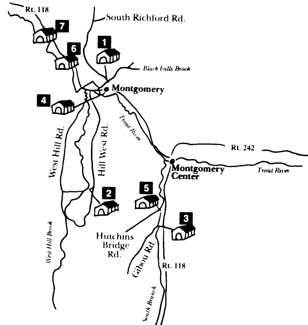
1. Fuller, 2. Creamery, 3. Hectorville (Gibou Road) – no covered bridge currently there, 4. Comstock, 5. Hutchins, 6. Longley, 7. Hopkins
